click on pictures to enlarge
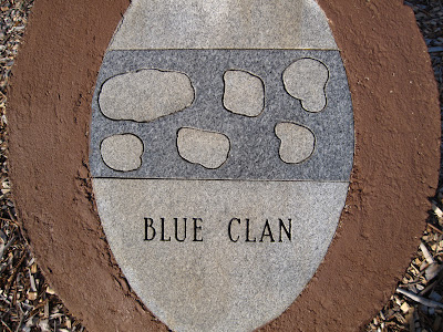
I just got through the second day of three off from work and it seems all I have done is repair and service equipment. It has to be done to keep the adventures going. Today I replaced a worn out tire on the boat trailer. We definitely have to have that piece of equipment in constant working order. What I thought would take an hour turned out to take two and a half hours. Trailer tires are really hard to change and it's just as difficult getting the new tire to hold air. Long story and won't get into it here. Last week I changed the gearing on the motorcycle to make it more highway friendly. Big mistake! I changed the gearing back to factory early this afternoon. It was too late in the day to start an adventure on the water so I took off on the bike to see what I could turn up. I headed for Chota. I haven't been there in years and it was within my reach this afternoon. The shot below is the best I could get. The stone was sitting on a sharp angle to level. The large print are readable at least.
Chota was the name of the principle town of the Overhill Cherokee. It was the capital (lack of a better word) of the Cherokee people from the mid 1740's until around 1787. There was another principle Cherokee town, Tanasi, that existed at the same period as Chota. I get the two towns mixed up because Tanasi was THE principle town and later Chota became number one. A principal chief named Oconostota emerged from Chota as top dog of the Cherokee people. Both towns are now under water due to the construction of the Tellico Dam in 1979. The graves of Chota were opened and the bodies reentered at the Sequoyah Museum located on Route 360 South of the town of Vonore, Tennessee. It's interesting to note that a gentleman named John Sevier raided and burned both Cherokee towns in 1788 in reprisal for Cherokee acts of war upon local families at the time. Mr. Sevier later went on to become the first governor of Tennessee. By the way; the term Tanasi is the word that eventually instigated the name of this state---Tennessee. Whew! There's a bit of history for you. Oh, by the way; The old chief Oconostota is actually buried at the Chota monument. He is the only body there.
The Chota monument consists of eight pillars. A pillar for each of the seven Cherokee clans and one for the Cherokee nation. I've shown them below:
Finally the pillar that designates the Cherokee nation:
Below is a view of the pillars as they are grouped together.
When I look out over the lake it's difficult for me to envision what Tanasi and Chota looked like. I mean, the Little Tennessee River was the main waterway of the day. Tellico Dam is so huge that it erases even the minds ability to visualize what once was, but is now hidden beneath her water. Well, at least the old chief is at rest beneath a fitting monument to his people.
Chota is located in a scenic area that boasts beautiful views of the lake and the mountains.
I see an island in the shot above that is calling for a camp out adventure by canoe. The area surrounding the pillars is well kept by the Cherokee Indians. There is no litter anywhere which speaks loudly for the importance this sacred spot is to the first, true natives of this area.
Even the parking lot is immaculate. The monument lays a short walk from the parking area through beautiful manicured grasses and large expanses of cat tails and shoreline.
Douglas and Shade would have a ball running through those cat tails.
Every time I see a soft shoreline, I envision the Gheenoe parked with her bow just touching the soft sand.
The ground that Chota sits upon is protected from water erosion by the placement of large rocks all along the shoreline. Big boats make big wakes (waves) that are capable of changing the looks of a shoreline in as little as one boating season.
The pathway that leads from the parking lot to the monument is beautiful in itself. I am looking forward to coming here to listen to the whippoorwills and chuck wills widows mid March.
I had better saddle up and go put some miles on the bike. It is running flawlessly and I am enjoying the afternoon on it. I believe I'll go exploring.
Mt. Pleasant Road. Now, here is someplace I've never been. Here we go.
Check out that old, old building above. This is the Tennessee I know. Tennessee sure ain't Pigeon Forge or Gattlinburg. Those are for the tourists and a lot of tourists visit there. This, where I am standing, is Tennessee. When I see a trail like the one below; I am drawn to it like a magnet. I wonder what is up there? Maybe someday I'll take the KLR up that little trace.
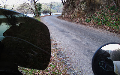
I'm beginning to understand where I am in relation to Route 129, which is across the lake from here. There are camp grounds on this side of Chilhowee Lake that I've seen from the highway. I've always wondered how to access them by road. Now I know. The road has become narrow and littered with gravel. This is getting interesting.
Above is Chilhowee Dam. It looks strange when viewed from this side. Route 120 runs along the mountain on the other side. This road will surely lead to those elusive camp sites I've wondered about.
The camping is free. Unbelievable! Free! The camping areas appear clean and they all are on the edge of the lake with access. What a nice place! I'll bet they fill up fast in the Summer months.
These camp sites are perfect for a person or a family who has a small fishing boat or canoe. The entire weekend could be made into an exciting adventure. Chilhowee is a huge body of water and would entertain fishermen and families alike. This is a very nice, clean camping area. It's nice to see that people are taking pride in the privilege of using it. The lake access site is even nice. Sometimes they are less than desirable. However, they are not for Douglas and me. We like elbow room.
It's time to get on up the road. I think I'll run this to wherever just to see what I can see. I've never been on this one. Ah; a delightful little waterfall. Maybe I should say a tall waterfall.
I sure wouldn't want to run off the edge of this road.
The hard pavement is starting to become broken and gravel is quickly replacing the asphalt. Yep; saw it coming. Guess we'll be on gravel from here on out.
I've been on this road now for eighteen miles and there hasn't been a road shooting off to either side in all that time. I've got no idea where I am. All I know is the road has been on the incline the whole time. It has carried me far back into the mountains. I can't get my bearings because of all the curves and sharp turns that take me in several directions in short order. The properties along the route are, shall we say, adequate housing. These are homes of average Tennesseans with average or below average incomes. Most are neat but, there is always that "special looking place."
Now, now; don't be hasty and start thinking ill of the nice folks residing on the property above. It takes a lot of years to accumulate all those possessions. Many folks like to make the most of their purchases and are reluctant to let them go just because they show a bit of age. Besides; I can't imagine where a fella would take his junk to around here. The nearest town is, well, out there somewhere. The folks above are probably waiting until they have enough junk to make a truck load and will take it to the refuse pile in one run. Ya; that's it.
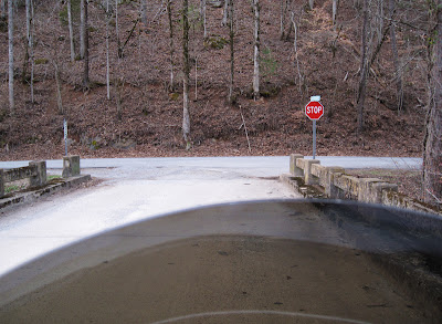
I still have no idea where I am. All I know is that this road has turned to gravel miles back and continues to climb up into the mountains. I'm glad I have a six gallon tank of gas. Actually, I'm glad I filled the tank up before venturing out this afternoon. At last; the road is descending the mountain. I was getting worried there for awhile. At last; a stop sign. But, no signs indicating my location. Perfect! We'll go right. Seems like right is correct.
Now what? Where am I? Could I be in North Carolina? Route 129 runs into North Carolina. I've been riding now for over 25 miles and most of those miles were on gravel. I could be anywhere.
Oh no! Give me a break! I know where Citico Camp Ground is. That road took me on a big 25 mile circle and brought me back to a spot about a mile away from the Chota monument. How bout that?! Amazing! Now, just what was someone thinking when they designed that long piece of road? All it amounts to is a 25 or 28 mile loop through nothingness only to return to the beginning. Strange place this Tennessee. Mighty strange!
It's been a delightful afternoon with some pleasant twists and turns. I thoroughly enjoyed the motorcycle and am happy with the way it runs. You didn't notice, I'm sure, but the windshield is held on with duct tape. I hit a turkey the other day and the bolts that secure the shield in place fractured the plastic shield. A new one is on it's way. The rest of the ride home was uneventful so I won't make mention of it here. I found a new road and learned how to access the camp sites on the other side of Chilhowee Lake. The time was well spent this afternoon not to mention very enjoyable. Ha; I guess the ride was a mini adventure. See ya next time. Thanks for tuning in to my blog.
This blog is a visual record of my outings into the streams, lakes and forests of Tennessee and North Carolina by canoe, motor boat and motorcycle. I love photography and use that venue to record wildlife and wilderness scenes for my personal enjoyment. I enjoy writing short stories also and do so while out in the forests or on the lakes. I also am addicted to dogs as will be apparent as you read my blog. But, the canoe is my favorite means of escape and wilderness camping is a joy.
 T
T


No comments :
Post a Comment
I appreciate your interest in my blog and welcome your comments