I thought Cherokee Lake (The Rock Quarry) was about as defective as a lake could get as far as ascetics was concerned. Well; I was wrong. Starting January 1, 2011 my efforts will be directed onto a new lake named Douglas. Ironic, isn't it? My golden boy's name was Douglas. I have never been on Douglas Lake, and the end of December is just around the corner so, I thought I better get a look at this beauty.
Douglas Lake was constructed in 1943 for the purpose of flood control and hydroelectric power generation. It and Cherokee Lake are the insurance policies for flood protection in the Tennessee Valley. The dam is created by damming up the French Broad and the Nolichucky Rivers. Douglas has 550 miles of shoreline with a surface area of greater than 30,000 acres. It is a twisty, narrow lake lacking the width of Cherokee. Douglas Lake is 43 miles long and has a maximum depth of 140 feet at full pool. (measured from sea level).
Douglas Lake, to me, is what Death Valley National Monument would look like with water in it. I'm serious about that. The topography is a perfect match. Take the water all out of Douglas Lake and you have Death Valley's brother, Dying Valley.
All kidding aside; a reservoir would be useless as a flood control mechanism if it went through flood season at full pool. It is what it is. Again; I view this lake as a "job, or work" lake and have no interest in it for beauties sake. I'm sure glad I have the mental capacity to do that.
 |
| Boat ramp at Douglas Dam |
The sunrises in Tennessee are spectacular, especially if there is water under them. Sunrises are the main reason I like to get to the boat ramps and the lake before sunup.
The water at the boat ramp was 40 feet deep and everything looked safe to run the engine at red line for awhile. That thing needed to see some high RPM's.
 |
| Falcor was diggen it! |
 |
| I wonder if he could get blown off the deck? |
You can see in the shot above we are in big water. Ha; looks are deceiving.
That top number on the right side of the screen is depth. It reads 5.6 feet deep. Wow! The river channel widens and loses depth. Then it narrows and regains it's depth. Look at the shot below. That water is no more than 5 feet deep clear out to the center of the lake. There is only one path, the river channel, that is deeper and it is only 15 feet deep at the current time and it runs close to the shoreline.
We stayed directly over the river channel which kept us close to the shoreline. I was loading the GPS with point markers and data about shallow areas and river mouths. This data would be very beneficial in the future.
I noticed a very strange boat dock. I chuckled when I saw it.
 |
| Maybe the guy has a tall boat. |
This is one of those guys who lives right on the lake. I love that description of where people live when asked. "We have a place right on the lake." Right! And, that's your boat dock-------up there.
I guess it would be a cool place to just go hang out, if one likes to be in the wind. I would hope the beer and alcohol were left above in the house though. All right; I'll let it go....
Maybe it's the stairway to heaven. Oops! Sorry. But, the water belongs up there under the boat dock.
The mountains add a beautiful back drop to the lake. This is Douglas's one saving grace. The mountains can dress up the poorest wretch.
Then something didn't look quite right on the surface far ahead.
 |
| Dandridge boat ramp |
We motored past the Dandridge boat ramp and under the Route 92 bridge and got covered up in floating wood and garbage. Wow! It spanned the entire lake shoreline to shoreline. What's a guy to do now? First time for this.
 |
| Perfect canoeing water |
We're going right through it. Then the stern end of the boat lifted slightly and moved sharply to the right. We were only idling so it was no big deal. A log became lodged between the lower unit of the motor and the boat's hull.
I simply raised the motor and pried the log away from the engine with a long ten foot wooden pole I carry for just such emergencies.
We were back in motion again. Not for long. Now, we picked up a tree limb that was floating subsurface.
We broke through the floating wood and I put some speed to the boat and we caught a tree limb I didn't see. It was a little tricky to get off the engine.
 |
| Don't want to hit that baby! |
That is so funny to me. I mean; look how far up on that cliff that boat dock is!
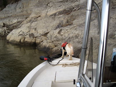
We wouldn't be staying here long so I'll leave his life vest on. He just needs a ten minute break and we'll be heading back toward the dam.
The rest of the drive to the dam was uneventful. I really wanted to go to where the Nolichucky River flows into the dam but, it can't be done. The water is too shallow. Maybe I can truck around the shallow sections and launch the boat above those areas and reach the Nolichucky that way. We'll see. It's all part of the fun.
There were still some renegade lone wolf logs floating about. We'd have to be careful.
My coworkers tell me that the bottom of Douglas Lake is mud. The sonar reinforces that statement. Cherokee, on the other hand, is rock. I don't want to ground out the engine on either one. It's going to be an interesting Winter on the lakes. I gathered data and entered it in the GPS/sonar unit this morning. It was time very well spent. Now, at least I have an idea where I can and can't go. I have the best job on the planet. Hope you enjoyed the boat ride today.
Ya ain't missin anything on these lakes, Douglas. But, I'm missing something...You!


I've gone canoeing a couple of times from the Dandridge boat ramp. If you cross the river and go about a mile, keeping the bank on the right, you come to Henderson Wildlife Refuge, which is pretty nice. Well, I think it's pretty nice, anyway. I saw four otters playing together out there once.
ReplyDeleteI've never seen Douglas all full of driftwood like that, but I would take my canoe into it, sure. It would be fun to maneuver around all those logs to pick up those bottles and throw them away. Wood is soft enough that it doesn't leave a mark if you hit it. If there's enough of it, you can't get through and you have to back out, but it doesn't look that thick, and backing out is not that big a deal anyway.
Cat
I did enjoy my boatride, but I had to go turn up the heat a little...brr! We depend on our GPS to give us heads up on obstacles. Wonder what had caused all that debris in the lake, have you had heavy rains? We had flooding on White River last spring and it muddied up Beaver Lake for a short time. You take for granted that crystal clear water! Be safe Gary...
ReplyDelete